- Introduction: Navigating the Law of the Seas
- Section 1: Territorial Sea and Contiguous Zone
- Section 2: Exclusive Economic Zone and Continental Shelf
- Section 3: High Seas, International Seabed Area, and Archipelagic Waters
- Maritime Zones Table: A Comprehensive Overview
- Conclusion: A Sea of Opportunities and Challenges
-
FAQ about Maritime Zones under the Law of the Seas
- What are the 12 nautical mile territorial waters?
- What is the contiguous zone?
- What is the continental shelf?
- What is the exclusive economic zone (EEZ)?
- What is the high seas?
- What is the legal status of the seabed beyond the limits of national jurisdiction?
- What is the role of the International Seabed Authority (ISA)?
- What are the obligations of states under the Law of the Seas?
- How is the Law of the Seas enforced?
Introduction: Navigating the Law of the Seas
Greetings, readers! As we set sail into the vast expanse of international law, let us delve into the fascinating realm of the Law of the Seas. This intricate legal framework governs the oceans and maritime zones, shaping the interactions between nations and safeguarding the global maritime domain.
The Law of the Seas is a complex tapestry woven from international treaties, conventions, and customary practices. It defines the rights and responsibilities of states over maritime areas, ensuring the peaceful and equitable use of the oceans. By understanding these maritime zones, we gain insights into the legal landscape that guides the exploration, exploitation, and conservation of our precious marine resources.
Section 1: Territorial Sea and Contiguous Zone
Territorial Sea: A Nation’s Sovereign Domain
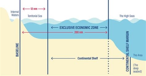
The territorial sea is a maritime zone adjacent to a nation’s coastline, typically extending 12 nautical miles from the baseline. Within this zone, the coastal state exercises full sovereignty, akin to its land territory. This includes jurisdiction over navigation, fishing, mineral exploration, and other activities.
Contiguous Zone: Extending Enforcement Capacity
Beyond the territorial sea lies the contiguous zone, an area where a nation can exercise limited control for enforcement purposes. The contiguous zone extends 24 nautical miles from the baseline, and within its confines, the coastal state has the right to enforce its customs, immigration, sanitary, and fiscal laws.
Section 2: Exclusive Economic Zone and Continental Shelf
Exclusive Economic Zone: Harnessing Ocean Resources
The exclusive economic zone (EEZ) is a vast maritime area extending 200 nautical miles from the baseline. Within this zone, the coastal state enjoys exclusive rights to explore, exploit, conserve, and manage the natural resources of the seabed, water, and subsoil. This includes fisheries, oil and gas, and other valuable marine resources.
Continental Shelf: Extending Sovereign Claims
The continental shelf is a submerged extension of a coastal state’s landmass, extending beyond the EEZ. The coastal state has sovereign rights over the seabed and subsoil of the continental shelf, including mineral resources and hydrocarbon deposits. The extent of the continental shelf can vary depending on the geological characteristics of the seabed.
Section 3: High Seas, International Seabed Area, and Archipelagic Waters
High Seas: Freedom and Common Heritage
Beyond the EEZ and continental shelf lie the high seas, an area where all nations enjoy freedom of navigation, fishing, and other lawful uses. The high seas are not subject to the sovereignty of any state, and international law governs the activities of nations within this vast expanse.
International Seabed Area: A Global Commons
Beyond the limits of national jurisdiction lies the international seabed area. This vast underwater territory is the common heritage of all mankind and is governed by the International Seabed Authority. The exploration and exploitation of mineral resources in this area are subject to international regulation, ensuring the equitable distribution of benefits.
Archipelagic Waters: Navigating an Archipelago
For nations composed of multiple islands, the Law of the Seas recognizes archipelagic waters. These waters are enclosed by a series of straight baselines connecting the outermost islands of an archipelago. Archipelagic waters are considered internal waters over which the coastal state exercises full sovereignty.
Maritime Zones Table: A Comprehensive Overview
| Maritime Zone | Distance from Baseline | Rights and Responsibilities |
|---|---|---|
| Territorial Sea | 12 nautical miles | Full sovereignty |
| Contiguous Zone | 24 nautical miles | Enforcement jurisdiction |
| Exclusive Economic Zone (EEZ) | 200 nautical miles | Exclusive rights to explore and exploit natural resources |
| Continental Shelf | Variable extent | Sovereign rights over seabed and subsoil |
| High Seas | Beyond the EEZ and continental shelf | Freedom of navigation and other lawful uses |
| International Seabed Area | Beyond national jurisdiction | Common heritage of mankind |
| Archipelagic Waters | Encircled by archipelagic baselines | Internal waters with full sovereignty |
Conclusion: A Sea of Opportunities and Challenges
The Law of the Seas maritime zones provide a framework for understanding the legal boundaries and rights of nations over the world’s oceans. This intricate legal landscape governs the allocation and use of marine resources, protects the environment, and ensures the peaceful coexistence of nations.
As we continue to explore the depths of our oceans, the Law of the Seas will continue to guide our interactions and shape the future of our maritime domain. Understanding these maritime zones is essential for mariners, policymakers, and anyone seeking to navigate the complex world of international law.
Readers, I invite you to delve deeper into this fascinating subject by exploring our other articles on maritime law. Together, we can unravel the mysteries of the deep and foster a greater appreciation for the law of the seas and its role in shaping our global society.
FAQ about Maritime Zones under the Law of the Seas
What are the 12 nautical mile territorial waters?
The territorial waters are an area of the sea extending up to 12 nautical miles from the baseline of a coastal state. Within this area, the coastal state has full sovereignty, including the right to regulate all activities.
What is the contiguous zone?
The contiguous zone is an area of the sea extending up to 24 nautical miles from the baseline of a coastal state. Within this area, the coastal state has the right to enforce its customs, fiscal, immigration, and sanitary laws and regulations.
What is the continental shelf?
The continental shelf is the seabed and subsoil of the submarine areas that extend beyond the territorial waters to the outer edge of the continental margin. The coastal state has exclusive rights to explore and exploit the natural resources of the continental shelf.
What is the exclusive economic zone (EEZ)?
The EEZ is an area of the sea extending up to 200 nautical miles from the baseline of a coastal state. Within this area, the coastal state has sovereign rights over the exploration and exploitation of all living and non-living resources of the sea.
What is the high seas?
The high seas are the parts of the sea that are not included in the territorial waters, contiguous zone, EEZ, or continental shelf of any state. The high seas are open to all states for activities such as navigation, fishing, and scientific research.
What is the legal status of the seabed beyond the limits of national jurisdiction?
The seabed beyond the limits of national jurisdiction is considered to be the common heritage of mankind. It is to be used for the benefit of all states, irrespective of their geographical location or level of development.
What is the role of the International Seabed Authority (ISA)?
The ISA is an international organization that was established to regulate activities on the seabed beyond the limits of national jurisdiction. The ISA has the power to issue licenses for exploration and exploitation of mineral resources on the seabed.
What are the obligations of states under the Law of the Seas?
States have a number of obligations under the Law of the Seas, including the obligation to:
- Respect the sovereignty and territorial integrity of other states
- Protect and preserve the marine environment
- Cooperate with other states in the management of marine resources
- Settle disputes peacefully
How is the Law of the Seas enforced?
The Law of the Seas is enforced through a combination of international cooperation and national enforcement measures. The International Tribunal for the Law of the Seas (ITLOS) is the principal body responsible for resolving disputes relating to the Law of the Seas.
